Colorado boondocking snapshot
Colorado rewards elevation flexibility and punishes late-day improvising on narrow mountain roads.
Best broad window
Late June through September
Many high-elevation routes need snowmelt, road drying, and open forest access before they make sense for RVs.
Best shoulder move
Western Slope and lower elevation
When the high country is still closed, muddy, smoky, or cold, lower routes often keep the trip simpler.
Main operational risk
Road season plus fire status
A legal public-land area can still be the wrong camp if the approach road, restrictions, storm exposure, or exit plan is weak.
Pick the lower fallback before the high camp
Colorado planning works better when the backup camp is chosen before the postcard camp. A high-elevation forest site can be legal, beautiful, and wrong if a storm, closure, fire order, altitude headache, or narrow road removes your margin.
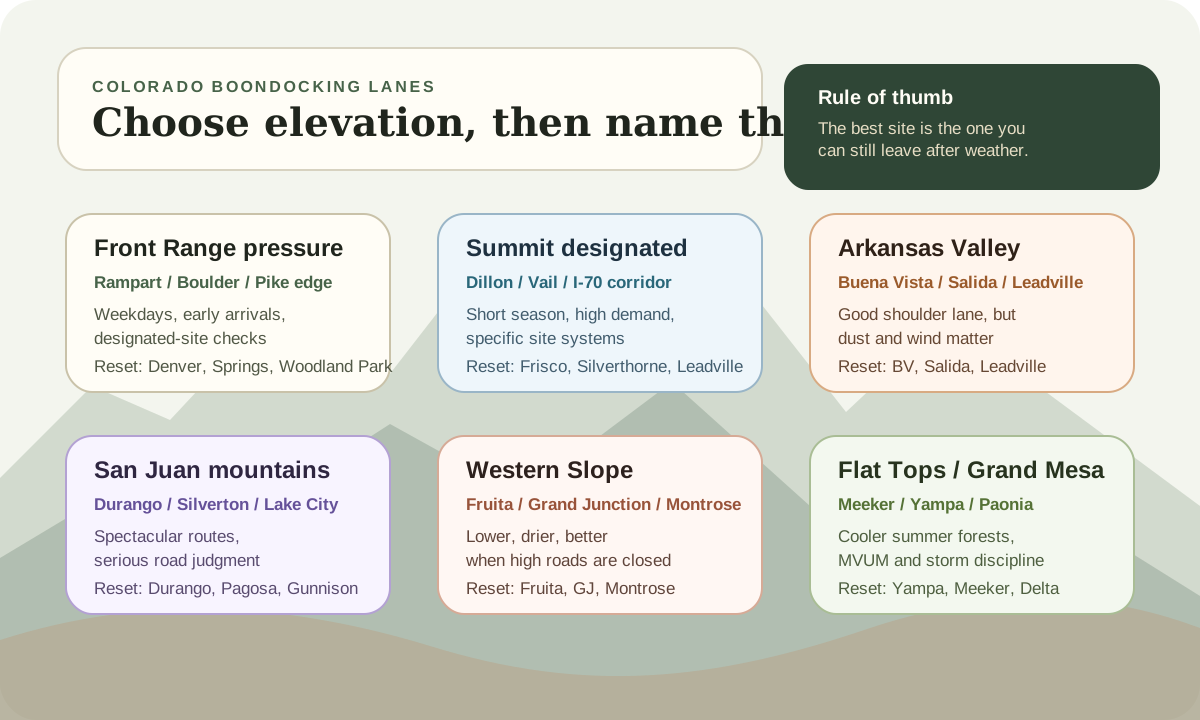
For each lane, name the lower or easier recovery point first. That might be Woodland Park before Rampart Range, Frisco or Silverthorne before a Summit County forest road, Buena Vista before a Leadville-area climb, Durango or Pagosa before a San Juan route, Fruita before Rabbit Valley, or Meeker before a Flat Tops road.
This is not pessimism. It is how you keep a Colorado trip from becoming a towing recovery story. The best high-country site is the one you can still leave after hail, rain, mud, smoke, or a cold night.
A faster Colorado pre-arrival check
Before leaving pavement, write down the managing agency, the road-status source, the fire-restriction source, the next water or dump reset, the lower-elevation fallback, and the first place you can turn around. If one of those is vague, the site is not ready.
Official planning links
Use these as verification starting points before you commit to a dispersed campsite.
Pre-arrival checks
Confirm the road is open and RV-realistic
Snowpack, mud, washouts, grades, and one-lane shelf roads can make a legal dispersed area a poor RV choice.
Check fire restrictions twice
Colorado restrictions can vary by county, field office, forest, and date. Treat campfire plans as optional until the exact land manager confirms them.
Set a lower or easier fallback
A calm Colorado plan includes a backup camp below the storm, snow, crowd, smoke, altitude problem, or rough-road pinch point.
Colorado is a short-season boondocking state
Colorado looks like endless summer camping from a distance.
For RVers, the usable season is narrower than the scenery suggests. Many of the camps people picture are high enough that access depends on snowmelt, road drying, storm timing, and whether the local forest or BLM office has current restrictions in place.
That does not make Colorado a bad boondocking state. It means the good strategy is seasonal and flexible.
On BLM land, do not treat a quiet site as an indefinite base camp. The current BLM Colorado camping and occupancy guidance uses a 14-days-in-30-days limit at one location and requires moving at least 30 air miles after that limit, with local rules still able to be stricter.
If you are new to dry camping, start with the boondocking beginner guide before chasing high-country sites. Colorado adds more variables than a mild desert test trip: elevation, grades, cold nights, fast storms, crowded trailheads, and fewer easy turnarounds.
Think in six Colorado lanes
Compare
Compare fast
Use one comparison matrix to scan the practical differences. Small screens stack each row; wider screens keep the first column pinned.
| Spec | Best window | What it solves | Main watchout | Reset / fallback |
|---|---|---|---|---|
| Front Range pressure lane | Weekdays, early arrivals, and open-road shoulder windows | Quick tests near Denver, Colorado Springs, Fort Collins, and Woodland Park | Designated-site rules, OHV traffic, enforcement sensitivity, and crowd pressure | Woodland Park, Denver, Colorado Springs, Nederland, or a paid developed site |
| Summit and I-70 designated lane | Late June through September, with storms and closures checked first | High-country access near Frisco, Silverthorne, Dillon, Vail, and Leadville | Designated dispersed restrictions, no-water sites, full trailheads, and cold nights | Frisco, Silverthorne, Dillon, Leadville, or a reserved campground |
| Arkansas Valley / Leadville lane | May through October depending on elevation, wind, and snowmelt | Buena Vista, Salida, Leadville, Twin Lakes, and drier shoulder-season options | Dust, wind, river-corridor pressure, lake-area restrictions, and exposed roads | Buena Vista, Salida, Leadville, or a paid Arkansas Valley campground |
| San Juan mountain lane | Mid-summer through early fall after roads dry | Durango, Pagosa, Silverton, Lake City, Ouray, and southwest mountain routes | Steep roads, mining-road temptation, storms, no services, and MVUM-specific access | Durango, Pagosa Springs, Gunnison, Montrose, or Lake City |
| Western Slope desert lane | Spring, fall, and lower-elevation backup windows | Fruita, Grand Junction, Rabbit Valley, McInnis Canyons, and Montrose-area resets | Heat, wind, OHV traffic, designated-camping zones, and longer water carries | Fruita, Grand Junction, Loma, Montrose, or a BLM developed site |
| Flat Tops / Grand Mesa forest lane | Summer into early fall, with road status and storms checked | Cooler forest stays away from I-70 and Front Range crush | MVUM rules, no-water sites, elevation swings, mud, and long service gaps | Yampa, Meeker, Rifle, Delta, Cedaredge, or Paonia |
The Front Range has easy access from Denver, Colorado Springs, Fort Collins, and the I-25 corridor. That convenience is also the problem. Roads fill, designated sites go quickly, and marginal pullouts draw more attention because more people are competing for the same close-in escapes.
High-country forest routes are the classic Colorado dream. They can also be the wrong first move for a large trailer, low-clearance Class C, or any rig without a calm reverse-and-turnaround plan. Beautiful does not mean recoverable.
The Western Slope and lower-elevation lanes often make better RV sense when the high country is not ready. They may not deliver the same alpine postcard, but they can give you easier solar, warmer nights, fewer grades, and a cleaner backup plan.
Named Colorado areas worth understanding
The point is not to publish a list of hidden campsite coordinates. The point is to understand what each Colorado lane is good at, what can go wrong, and where the next reset lives.
Front Range, Rampart Range, and West Magnolia
Use this lane when you want a short systems test, not a wilderness fantasy. Front Range routes are useful because Denver, Colorado Springs, Boulder, Fort Collins, and Woodland Park can stay within recovery distance. They are also the first places to feel weekend crowding, local restrictions, and enforcement pressure.
West Magnolia is a good example of why current official pages matter. The Forest Service describes it as designated campsites along eight miles of roads, with seasonal road closures, no facilities, and camping allowed in designated sites only. That makes it a planning problem, not a random-pullout problem.
Rampart Range is similar in a different way. The official page frames the area around OHV use and says dispersed camping is available in designated sites only for a fee, with Rampart Range roads closed annually by December 1 and through winter. That does not make it useless. It makes it a high-pressure, rules-forward Front Range option where noise, fees, road season, and turnaround space need to be accepted before you go.
Summit County, Dillon, Vail, and the I-70 corridor
This lane has the views people imagine when they search for Colorado camping. It also has some of the tightest pressure. The Dillon Ranger District page notes that dispersed camping in high-use areas is limited to designated sites, and that potable water and restrooms are not available at the district listing.
That means a "free high-country campsite near Frisco" search is the wrong starting point. The better starting point is: which designated area is open, what does the MVUM allow, where is the turnaround, and where do I go if every legal site is full by midafternoon?
Use Frisco, Silverthorne, Dillon, Leadville, or a reserved developed campground as the fallback. If the workday depends on signal, check the internet backup planner before treating a scenic valley as an office.
Buena Vista, Salida, Leadville, and the Arkansas Valley
The Arkansas Valley is one of Colorado's best RV planning lanes because it can bridge lower, drier shoulder-season camping and higher summer routes. Buena Vista, Salida, Leadville, and Twin Lakes all show up in real trips because they connect scenic access, services, water, dump options, and paved-road recovery.
Do not let that convenience hide the rules. The Leadville Ranger District page says dispersed camping is allowed except where marked prohibited or in specific recreation areas such as Turquoise and Twin Lakes under special order. It also keeps motorized dispersed camping within a tight route-based framework, not a "drive wherever the view opens up" system.
The practical move is to separate the town reset from the campsite. Fill water and handle waste before the climb. If the lake-area rule set or crowd pressure is not working, use Buena Vista, Salida, or Leadville as the recovery plan instead of pushing deeper up a rough road near dark.
San Juan mountains, Durango, Silverton, Lake City, and Pagosa
The San Juans are where Colorado gets spectacular and unforgiving at the same time. Durango, Silverton, Lake City, Ouray, Pagosa Springs, and the forest roads around them can be excellent, but they also put grade, weather, mining-road temptation, and no-service assumptions into the same trip.
The San Juan National Forest dispersed camping guidelines are blunt about the self-contained part: dispersed camping has little or no facilities, visitors need to know the rules, and camps should stay away from water. The same page points readers back to Motor Vehicle Use Maps for where motorized dispersed camping is legal.
For RVers, the good San Juan plan is conservative. Reject narrow roads early. Do not confuse an adventure-bike route with a travel-trailer route. Keep Durango, Pagosa, Gunnison, Montrose, or Lake City named before the weather turns.
Western Slope, Grand Junction, Fruita, and Rabbit Valley
The Western Slope is the lower, drier counterweight to the alpine dream. It can work when high roads are still closed, when altitude is wearing people down, or when you need sun and services instead of forest shade.
Rabbit Valley and McInnis Canyons show why western Colorado still needs rules. The official McInnis Canyons page says Rabbit Valley dispersed camping is allowed only in designated numbered and signed sites, and that a fire pan plus portable toilet are required for dispersed camping. The Jouflas Campground page lists the campground inside the Rabbit Valley Motorized Area, with no use fee, a toilet facility, pack-out trash expectations, and a 7-day stay limit.
This is not the place to treat open desert as empty desert. Expect OHV activity, wind, exposed sun, signed designations, and long-feeling water trips. Fruita, Grand Junction, Loma, and Montrose are the reset anchors that make the lane work.
Flat Tops, Grand Mesa, and northern forest routes
Flat Tops and Grand Mesa-style routes can feel calmer than the I-70 or Front Range lanes, but they still demand real road judgment. The official Flat Tops page points campers to MVUMs for dispersed camping areas, notes that campers may set up up to 300 feet off the road where allowed, and lists no potable water or restroom availability at the area page.
That same page also says the Flat Tops Wilderness ranges from 7,640 to 12,354 feet. In RV terms, that means cold-night swings, storm timing, generator margin, and water planning are not side notes.
Use Yampa, Meeker, Rifle, Delta, Cedaredge, Paonia, or a developed campground as the recovery layer. If the forest road is narrowing or the surface is softening, the first workable site is often better than the perfect one around one more bend.
Elevation changes the whole rig
Colorado altitude affects more than how hard the hike feels.
At higher elevations, nights can swing colder than expected. A campsite that feels perfect at 3 p.m. can ask a lot more from the furnace, battery, and water system after midnight. If you run lithium batteries in shoulder-season conditions, read the cold-weather lithium battery guide before assuming the bank will accept a charge every morning.
Propane appliances and diesel heaters also deserve respect at elevation. Some equipment runs fine, some needs adjustment, and some becomes less reliable when the air gets thin or temperatures drop hard. That is not a reason to avoid Colorado. It is a reason to test heat, ventilation, and fuel strategy before the remote site becomes the test bench.
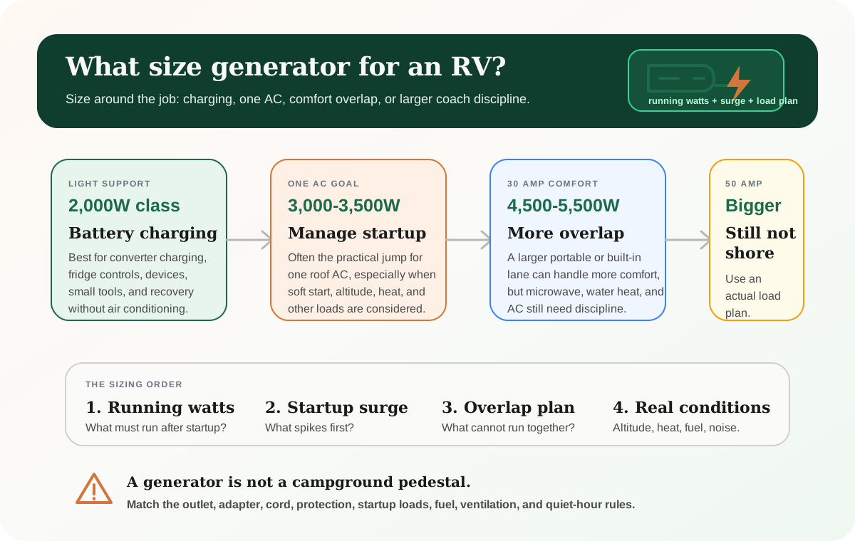
If your comfort plan leans on a generator, use the RV generator sizing guide and keep altitude derating in mind. A generator that feels adequate at lower elevation may have less margin up high, especially if air conditioning, battery charging, or heavy AC loads overlap.
Road season matters more than map distance
Colorado road mistakes usually start with overconfidence.
A road can be short, scenic, and still wrong for your rig. The practical questions are:
- can the rig turn around without depending on another camper moving
- does the road stay wide enough after the first good-looking pullout
- is there a grade or switchback that makes backing out miserable
- what happens if rain, snowmelt, or hail changes the surface
- will the exit still feel reasonable tomorrow morning
This is where crowd-sourced pins need a second opinion. Use the site-finding process in how to find legal boondocking sites, then verify with the official forest, BLM office, motor-vehicle map, and current road conditions.
The right Colorado camp is often the one you can leave easily. That sounds less romantic than the last pullout at the end of a rough road, but it keeps travel days from turning into recovery days.
Fire restrictions and afternoon storms are part of the plan
Colorado fire rules can change quickly. A campfire-friendly trip plan is fragile if it depends on one map screenshot from last week.
Before you build any camp routine around a fire, check the county, the local federal land agency, and the current restriction page. Even when fires are allowed somewhere nearby, your exact campsite may have different rules because of field-office boundaries, forest orders, developed-site requirements, or drought conditions.
Afternoon storms deserve the same respect. In mountain country, a clear morning does not guarantee a quiet evening. Lightning, hail, wind, and fast temperature drops can all turn an exposed ridge or meadow into a poor overnight choice.
The calmer pattern is simple:
- arrive earlier than you think you need to
- keep the awning conservative
- avoid depending on a campfire for warmth or cooking
- park where the exit does not require crossing a fresh washout or muddy slope
- choose shade and solar access as a system tradeoff, not a decoration choice
Water and service gaps decide how long the camp lasts
Colorado makes it easy to spend a day getting to camp and then realize the nearest practical water or dump option is not convenient.
Fill before climbing unless you have a confirmed refill plan near the route. Mountain towns may have services, but that does not mean they are close, cheap, open, or easy with a trailer. If your stay length depends on showers or dishwashing habits, run the water calculator before you commit to a multi-night high-country site.
Water planning is also weight planning. Carrying full fresh tanks into the mountains can change towing feel, braking margin, and site access. For some rigs, the best answer is not maximum water at every moment. It is enough water to stay comfortable plus a known refill lane that does not require a rough-road gamble.
What makes Colorado different from desert boondocking
If you are coming from Arizona, Nevada, or Utah desert routines, Colorado asks you to change the order of decisions.
In the desert, exposure, heat, wind, and water usually dominate first. In Colorado, road season and elevation can become the first filter. A shaded pine site may be cooler and prettier, but it can also cut solar harvest, hide muddy exits, and make nighttime heat a real battery and propane load.
That is why Colorado pairs well with shorter test stays. A two-night camp near a known reset teaches more than a seven-night commitment at the end of a road you have not driven before. Run the stay length calculator, name the water reset, and keep the first trip boring enough that the second one can be better.
The cleanest Colorado strategy
The cleanest Colorado boondocking strategy is not to chase the highest camp you can reach.
It is to pick the elevation that matches the season, road, rig, and recovery plan.
Use this order:
- choose the broad lane first: Front Range, Summit/I-70, Arkansas Valley, San Juan, Western Slope, or Flat Tops/Grand Mesa
- verify the land manager and current camping rules
- check road status, fire restrictions, weather, and storm timing
- arrive early enough to reject a bad site
- keep a lower-elevation backup that still works after dark
- protect water, heat, and exit plans before scenery gets a vote
That approach may skip a few dramatic camps. It also keeps Colorado from becoming a story about towing stress, generator struggle, frozen water, or a road you should not have taken.
If the next leg moves from high country to desert or coast, switch to the California boondocking guide before carrying Colorado assumptions west. The biggest risk shifts from elevation access to jurisdiction, permits, fire orders, and legal overnight boundaries.
For a wetter, Pacific Northwest version of the same route discipline, use the Oregon boondocking guide. Road season still matters, but rain, mud, state-forest rules, high-desert service gaps, and coastal overnight limits become louder than altitude.
For a northern version, use the Montana boondocking guide before chasing Glacier or Yellowstone routes. The road-season thinking carries over, but food-storage orders, bear-aware camp routines, and longer service gaps need their own plan.
Frequently asked
Questions RVers usually ask next.
When is the best time to boondock in Colorado?
For many RVers, late June through September is the most practical broad window for high-elevation routes. Lower-elevation Western Slope and Arkansas Valley options can work outside that window, but road conditions, fire restrictions, cold nights, and services still need to be checked before arrival.
Can big RVs boondock in Colorado?
Yes, but bigger rigs need a conservative road filter. Prioritize wide approaches, confirmed turnaround space, lower grades, and camps that do not require threading through crowded trailheads or narrow forest roads.
Where should a first Colorado boondocking trip start?
Start near a reset town and a simpler legal area, not at the end of a high mountain road. Front Range shakedowns, the Arkansas Valley, and some Western Slope lanes can be easier first tests than remote San Juan or Flat Tops routes.
Do I need to worry about altitude in an RV?
Yes. Altitude can affect people, generators, propane appliances, diesel heaters, nighttime temperatures, and battery charging assumptions. Test heat and charging systems before relying on them at a remote high-country site.
Are campfires allowed while boondocking in Colorado?
Do not assume they are. Fire restrictions can vary by county, BLM field office, national forest, and date, so verify the exact campsite with the current official restriction source before planning around a fire.
Freshness note
Last checked April 21, 2026
This topic can change when products, plans, prices, campsite rules, or fit guidance move. These notes show what was reviewed most recently.
This review included
- Rechecked official BLM Colorado camping and occupancy guidance, BLM fire-restriction routing, USFS Rocky Mountain Region entry points, and COtrip road-condition tools.
- Checked official Forest Service pages for West Magnolia, Rampart Range, Dillon Ranger District designated dispersed camping, Leadville Ranger District dispersed camping, San Juan dispersed camping guidelines, and the Flat Tops area.
- Checked official BLM McInnis Canyons and Jouflas/Rabbit Valley camping pages for Western Slope designated-camping and service-limit planning.
- Expanded the guide from three broad Colorado lanes into six practical lanes with named reset towns, road-season filters, and lower-elevation fallback logic.
- Added a Colorado-specific lane-board visual and a lower-fallback planning section so readers pick the recovery plan before chasing high-elevation campsite pins.
Recent change log
April 21, 2026
Expanded the Colorado guide with a lane-board visual, named Front Range, Summit, Arkansas Valley, San Juan, Western Slope, and Flat Tops planning lanes, plus stronger reset and official-source checks.
April 10, 2026
Published a Colorado boondocking guide with high-elevation lanes, Front Range pressure notes, Western Slope strategy, and official planning links.
April 10, 2026
Added Colorado-specific pre-arrival checks for road season, fire restrictions, altitude, afternoon storms, and next-service planning.
Broader editorial corrections are tracked on the Corrections and Updates page.