California boondocking snapshot
California can be one of the best RV states in the West if you plan by jurisdiction before scenery.
Best broad window
Desert winter, Sierra summer
Lower deserts are usually more comfortable from late fall through early spring, while higher forest routes make more sense after snowmelt and before heavy smoke or closure season.
Main planning risk
Boundary and permit mistakes
A legal camp on one side of a road can become a citation, tow risk, or impact problem if the land manager changes.
Best traveler fit
Rule-checking, water-ready RVers
California rewards RVers who verify the exact land manager, carry water honestly, and keep a legal fallback before sunset.
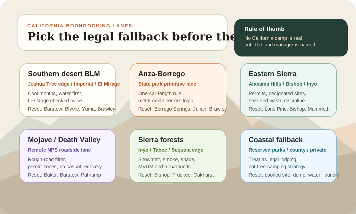
Pick the legal fallback before the campsite
California planning works better when the backup night is chosen before the dream site. A desert wash, granite view, or pine forest pullout can look perfect and still fail because the permit is missing, the road turns sandy, a fire order changes, or the coast has no legal overnight option left.
For each California lane, name the recovery point first. That might be Borrego Springs before Anza-Borrego, Lone Pine before Alabama Hills, Baker before Mojave, Pahrump before Death Valley, Bishop before an Inyo forest road, or a reserved state/county/private campground before a coastal travel day.
This is not over-planning. It is how you keep California from becoming a late-day scramble between "probably fine" and "not legal."
A faster California pre-arrival check
Before leaving service, write down the land manager, the active fire source, the current road source, the permit or designated-site rule, the next water or dump reset, and the legal fallback if every first-choice site fails. If one line is blank, the camp is not ready.
Official planning links
Use these as verification starting points before you commit to a dispersed campsite.
Pre-arrival checks
Name the land manager before camping
California routes can move between BLM, state park, national preserve, national forest, county, private, tribal, and coastal jurisdictions quickly.
Check fire rules before every trip
BLM California requires campfire permits for campfires and gas stove fires on public land, and local orders can be stricter than the broad statewide baseline.
Carry the water plan before the view plan
Desert camps, Sierra trailhead zones, and coastal fallback nights all get harder when the next legal refill or dump station is vague.
California is a boundary-and-permit state
California boondocking gets easier once you stop treating the state as one rule set.
The state contains classic BLM desert camping, state-park primitive camping, national-preserve roadside camping, national-park backcountry permits, national forest dispersed camping, county limits, private land, tribal land, paid coastal campgrounds, and heavily managed scenic areas.
That mix is the opportunity and the trap.
On BLM California public lands, the broad dispersed-camping rule is usually up to 14 days within a 28-day period at a specific location, followed by a move outside a 25-mile radius until the 29th day. The same official page flags exceptions, including Bishop Field Office limits, permit-sensitive areas, and places posted closed to camping.
That means the first useful question is not "Where is the pretty pin?"
It is "Who manages this exact campsite?"
If you need a repeatable site-finding workflow, use how to find legal boondocking sites before you start comparing famous California routes.
Think in six California lanes
Compare
Compare fast
Use one comparison matrix to scan the practical differences. Small screens stack each row; wider screens keep the first column pinned.
| Spec | Best window | What it solves | Main watchout | Reset / fallback |
|---|---|---|---|---|
| Southern desert BLM lane | Late fall through early spring | Solar-friendly dry camping near the Joshua Tree edge, El Mirage, Imperial, Jawbone, Rasor, and Blythe-style travel corridors | Heat, soft sand, OHV traffic, desert district fire stages, long water carries, and unclear private/public edges | Barstow, Blythe, Brawley, Yuma, Indio, or a known BLM developed site |
| Anza-Borrego state-park lane | Cooler months, with road and fire advisories checked first | Primitive desert camping inside a huge state park with services nearby in Borrego Springs | One-car-length parking rule, no illegal ground fires, road-condition changes, and 30-day annual occupancy limit | Borrego Springs, Julian, Brawley, Ocotillo Wells, or a reserved park campground |
| Alabama Hills / Eastern Sierra lane | Spring and fall for Alabama Hills; summer for higher Sierra routes after snowmelt | Iconic scenery, Highway 395 services, Bishop/Lone Pine resets, and access toward Inyo forest routes | Free designated-camping permits, first-come competition, human-waste control, Bishop Field Office limits, snow, smoke, and bear-aware storage | Lone Pine, Bishop, Independence, Mammoth Lakes, Tuttle Creek, or Portuguese Joe |
| Mojave / Death Valley lane | Winter and cooler shoulder windows | Remote national-preserve and national-park desert travel with big-space camping potential | High-clearance roads, mandatory permit corridors, extreme heat, weak service, no easy RV recovery, and water/dump scarcity | Baker, Barstow, Pahrump, Furnace Creek, Beatty, or a developed NPS campground |
| Sierra forest lane | After snowmelt through early fall, depending on smoke and forest orders | Cooler forest stays when the desert is too hot and the coast is too constrained | MVUM rules, narrow roads, shade versus solar tradeoffs, late openings, bear food storage, and rough turnarounds | Bishop, Truckee, Oakhurst, Sonora, Susanville, or a developed forest campground |
| Coastal legal-fallback lane | Any season if lodging is reserved and rules are confirmed | A legal reset between desert, Sierra, and city errands when free camping is not realistic | Overnight parking restrictions, private land, state/county/city enforcement, full campgrounds, and expensive last-minute options | Reserved state park, county park, private RV park, fairground, casino, or verified overnight lot |
The desert lane is the cleanest fit for many RVers. It gives you sun, open space, and the classic dry-camping rhythm. It also asks for honest water, heat, tire, fire, and road judgment.
The state-park and national-preserve lanes are where old internet assumptions get dangerous. Anza-Borrego, Mojave, and Death Valley are not generic public-land canvases. They each publish their own rules, road notes, fire limits, and permit systems.
The Sierra lane is different. It can be excellent in summer, but it behaves more like the Colorado boondocking guide: snowmelt, forest orders, smoke, shade, narrow roads, and turnarounds become the real campsite filter.
The coast is a legal-fallback lane, not a boondocking strategy. California's coastline has excellent campgrounds and reset towns, but highway pullouts and beach-adjacent streets are not a dependable RV overnight plan.
Named California areas worth understanding
This is not a hidden-campsite list. California does not need more fragile pins. It needs better pre-trip filtering so you know which areas match your rig, season, and rule tolerance.
Southern desert BLM, Joshua Tree edge, and OHV areas
Southern California BLM land can be the easiest first lane for self-contained RVers in cool weather. It has sun, space, and enough service towns to build a smart loop instead of a one-way gamble.
The names worth understanding are not secret. El Mirage, Imperial Sand Dunes, Jawbone/Butterbredt, Johnson Valley, Rasor, Stoddard Valley, Dumont, and the public-land edges around desert travel corridors all show up in official BLM California routing. Some are OHV-heavy. Some are permit or fee sensitive. Some are better as one-night travel stops than weeklong quiet camps.
The practical move is to choose the field-office area first, then check the exact fire stage and route. BLM California's fire page now breaks restrictions by district and field office. In parts of the desert district, Stage I and Stage II rules can change what is allowed for campfires, stoves, smoking, target shooting, and Red Flag conditions.
For first-timers, a boring desert site with an easy exit is better than a dramatic wash with no turnaround. If desert camping is your main route, pair this guide with the desert boondocking checklist before committing to a remote canyon, playa, or two-track.
Anza-Borrego
Anza-Borrego Desert State Park can be a great RV desert-camping zone because it has vast desert terrain, primitive camping options, and many dirt roads.
But it is a state park, not generic BLM land.
The official park page says vehicles along designated dirt roads must stay no more than one car length off the road where they will not disturb natural features. It also says illegal ground fires are prohibited, campfires must be in a camp stove or metal container with bottom and sides, and the entire backcountry area is defined as a camping facility with a 30-days-per-calendar-year occupancy limit.
That should change how you pick a site.
In Anza-Borrego, the cleaner RV strategy is:
- use existing disturbed areas instead of creating a new pullout
- keep the rig close to the designated dirt road
- treat fire as conditional, not assumed
- check current road conditions before trusting a map line
- carry more water than the campsite romance suggests
Borrego Springs is the obvious reset. Julian, Brawley, Ocotillo Wells, and reserved park campgrounds are the backup layer. If the park has a road closure, heat warning, or fire restriction that does not fit your rig, do not force the trip deeper.
Alabama Hills and the Eastern Sierra
Alabama Hills is one of the most photographed RV camping areas in California.
That popularity is exactly why the rules matter.
The BLM Alabama Hills page says camping permits are required for designated camping, the permits are free, and they do not guarantee a campsite. Camping is first come, first served. BLM also points visitors toward nearby campgrounds such as Tuttle Creek, Lone Pine, and Portuguese Joe.
For an RV, this means Alabama Hills is better as a managed scenic stop than as a vague dispersed-camping fallback.
The practical filter is:
- arrive with the free permit handled or know where to get one
- expect competition for legal designated sites
- have a nearby campground or alternate public-land plan
- pack out solid human waste or use available restroom facilities
- do not assume old online pins still represent legal camping
The broader Eastern Sierra lane adds its own decisions. Bishop, Lone Pine, Independence, Mammoth Lakes, and Inyo National Forest routes can make a strong summer or shoulder-season loop, but the same area can bring snowmelt, fire restrictions, bear-aware storage, busy trailheads, and routes that feel smaller than they look on a screen.
The best California boondocking plan does not depend on Alabama Hills being easy at sunset.
Mojave, Death Valley, and national-park boundary logic
Mojave National Preserve is tempting because it looks open and empty.
The National Park Service camping guidance for Mojave is more careful than that. It describes undeveloped roadside camping as an option for well-prepared, self-sufficient campers with vehicles suited to rougher road conditions. It also says most sites require high clearance and four-wheel drive, road conditions can change, and developed campgrounds are the better fit for less experienced campers and many RVs.
Death Valley adds an even sharper lesson: national-park backcountry camping is not one blanket permission. The NPS permit page lists several roadside corridors where permits are mandatory, and the main camping page warns that summer heat, primitive roads, poor cell service, and lack of water raise the consequence of a mistake.
That matters even if your RV technically fits down the first mile.
In this lane, the question is not just whether camping is legal. It is whether you can recover the rig if the road turns sandy, narrow, washed out, overheated, or blocked. A low-clearance van, long travel trailer, or heavy Class C may be better served by developed campgrounds, known roadside sites, or a more conservative BLM desert route outside the park or preserve.
Use Baker, Barstow, Pahrump, Furnace Creek, Beatty, Shoshone, or a developed NPS campground as the reset plan. If the route asks you to ignore temperature, water, tire, or clearance reality, it is not the right RV camp.
Sierra forests
The Sierra and other California national forest routes can be excellent summer relief after the desert gets too hot.
But they are not the same trip.
Forest camping adds:
- snowpack and late-opening roads
- shade that helps comfort but reduces solar harvest
- wildfire smoke and forest orders
- narrower roads and fewer big-rig turnarounds
- colder nights at elevation
- bear-aware food and trash storage
- more competition near lakes, trailheads, and famous corridors
The USFS Pacific Southwest dispersed-camping page is a useful reset because it reminds readers that dispersed camping has no amenities, stay limits can be further restricted by individual forests, and camps should stay well away from water. It also warns that rough, steep, or narrow roads can be dangerous for larger RVs.
Use the forest lane when the rig, battery, and water system fit the season. If the route depends on long workdays, check the internet backup planner before assuming the prettier camp can also support calls, uploads, or deadlines.
Coastal California
The coast is where a lot of California RV plans get emotionally expensive.
It is easy to look at the map and imagine a string of beach-adjacent free nights. That is not a plan. Coastal California is a patchwork of state parks, city rules, county rules, private land, no-overnight signs, tow-sensitive streets, and campgrounds that can fill months ahead.
That does not mean the coast is useless for boondockers. It means you use it as a legal reset:
- book a state, county, private, or fairground site before the travel day
- dump, refill, shower, and do laundry while you are there
- avoid building a trip around unverified highway pullouts
- leave enough daylight to switch plans if a lot or street is signed against overnighting
California's coast is worth visiting. It just should not be the place where your legal overnight plan depends on optimism.
Fire rules are not optional paperwork in California
California fire restrictions deserve their own planning step.
BLM California's fire page lists statewide, year-round criteria for campfires outside developed campgrounds, including a cleared area, a shovel, and a valid California Campfire Permit. It also lists district and field-office restrictions that can be stricter, including desert district stages and Red Flag limitations.
That means a campfire permit is not the same as permission to have a fire anywhere.
Treat fire planning this way:
- check the statewide source
- check the exact field office, park, forest, or preserve
- check county and local emergency restrictions
- assume rules can change during heat, wind, drought, or limited firefighting capacity
- cook without a fire if the rule set is unclear
The safest California camp is the one that does not need a campfire to work.
Water, heat, and distance decide the desert stay
California desert camping is where many RVers get the best off-grid payoff.
It is also where bad water math gets exposed fast.
Do not size the stay from fresh-tank capacity alone. Include drinking water, dishwashing style, dog water, dust cleanup, handwashing, showers, and the distance to the next legal dump or refill. Run the water calculator before stretching a desert stay just because the view is good.
Heat matters too. A sunny winter desert site can feel easy. A shoulder-season heat wave can turn that same site into a shade, fridge, battery, and pet-safety problem.
The better first trip is shorter than your tank capacity. Use the stay length calculator, pick a reset town, and learn the lane before stretching the full week.
What makes California different from Arizona and Nevada
If you are coming from Arizona or Nevada, California can feel stricter because the boundary changes are louder. A route can move from open BLM desert to a state park, national preserve, national park, county road, private parcel, or coastal city rule faster than the scenery changes.
That is why California is less about finding "free land" and more about matching the trip to the jurisdiction.
Arizona's winter desert loops often reward service-town spacing and heat management. Nevada often rewards distance, fuel planning, and tolerance for empty spaces. California rewards current rule checks, permit awareness, fire-stage discipline, and legal fallbacks.
The gear plan matters, but the paper trail matters first.
The cleanest California strategy
The cleanest California boondocking strategy is to plan by jurisdiction, then by season, then by campsite.
Use this order:
- choose the broad lane first: Southern desert BLM, Anza-Borrego, Alabama Hills/Eastern Sierra, Mojave/Death Valley, Sierra forest, or coastal fallback
- confirm the exact land manager and current camping rules
- check permit requirements, designated-site rules, and road restrictions
- check fire restrictions and campfire-permit requirements
- verify road conditions and RV turnaround reality
- set water, dump, and paid-fallback options before leaving service
- arrive early enough to reject a marginal site
- keep the camp low-impact enough that you would be comfortable explaining it to a ranger
California can deliver some of the best off-grid RV nights in the country.
The price of admission is not just gear. It is careful boundary work.
If the next leg moves north, switch to the Oregon boondocking guide before carrying California desert assumptions into the Pacific Northwest. The big variables become rain, mud, coastal overnight limits, state-forest rules, smoke, and high-desert water gaps.
If the next leg moves east, compare this with the Arizona boondocking guide before assuming every desert route has the same permit, fire, water, or reset pattern.
Frequently asked
Questions RVers usually ask next.
Is California good for RV boondocking?
Yes, especially in desert and some national forest areas. The catch is that California requires more exact land-manager checking than many RVers expect because rules change quickly between BLM land, state parks, national preserves, national parks, national forests, counties, private land, and coastal areas.
Can you boondock on the California coast?
Do not treat the coast as a dependable free-camping lane. Many coastal areas are private, city-regulated, state-park managed, or otherwise restricted, so use legal campgrounds or verified overnight areas instead of highway pullouts.
Do you need a campfire permit for California boondocking?
On BLM-managed public lands in California, campfires and gas stove fires require a California Campfire Permit, and active restrictions can still prohibit or limit fires. A permit is a baseline requirement, not blanket permission.
What is the easiest California boondocking area for first-timers?
A conservative BLM desert route in cooler weather is usually easier than a famous crowded scenic area or a narrow Sierra forest road. Pick a legal site with simple access, known water and dump options, and a paid fallback nearby.
Freshness note
Last checked April 21, 2026
This topic can change when products, plans, prices, campsite rules, or fit guidance move. These notes show what was reviewed most recently.
This review included
- Rechecked official BLM California dispersed-camping guidance, BLM California fire restrictions, Anza-Borrego Desert State Park regulations, Alabama Hills BLM camping guidance, Mojave National Preserve roadside-camping guidance, Death Valley National Park camping and permit pages, USFS Pacific Southwest dispersed-camping guidance, and Caltrans QuickMap.
- Expanded the guide from four broad California lanes into six practical lanes with named reset towns, land-manager warnings, permit-sensitive areas, and legal coastal fallback logic.
- Added a California-specific lane-board visual and a pre-arrival check section so readers verify jurisdiction, fire rules, road conditions, water, and fallback lodging before chasing campsite pins.
Recent change log
April 21, 2026
Expanded the California guide with a six-lane decision board, named Anza-Borrego, Alabama Hills, Eastern Sierra, Mojave, Death Valley, Southern desert BLM, Sierra forest, and coastal fallback planning notes.
April 11, 2026
Published a California boondocking guide with desert, state-park, national-preserve, Sierra, and coastal planning lanes.
April 11, 2026
Added California-specific pre-arrival checks for permits, fire restrictions, road access, designated-site rules, and legal overnight boundaries.
Broader editorial corrections are tracked on the Corrections and Updates page.


