Where should RVers boondock in Arizona?
The best Arizona boondocking plan starts with season and elevation, then narrows to a legal area that fits your rig. In winter, the low-desert lanes around Quartzsite, Kofa, Lake Havasu, Parker, Alamo Lake, Yuma, and Safford can be excellent. In shoulder seasons, Sedona and the east-of-Mesa Tonto edge are tempting but more regulated. In summer, the useful plan usually climbs toward Williams, Kaibab, Flagstaff, Prescott, Apache-Sitgreaves, or the Mogollon Rim.
That is the part most thin Arizona guides skip. "BLM land" is not enough. A good RV site also needs an exit road you can leave after weather, enough room to turn around, a known water reset, and current fire information.
If you are still building your public-land process, start with the legal boondocking site guide before trusting any app pin. If you are stretching a desert stay, run the water calculator before you decide the tank number is enough.
Arizona boondocking snapshot
Arizona rewards seasonal planning more than broad one-size-fits-all route planning.
Best broad window
Low desert: November through March
Quartzsite, Kofa, Lake Havasu, Alamo Lake, and Safford are usually easiest before sustained heat arrives and before water use climbs.
Best summer move
Climb in elevation
Williams, Kaibab, Prescott, Flagstaff, Apache-Sitgreaves, and rim-country routes can reduce heat load, but add shade, storms, seasonal road closures, and colder nights.
Main operational risk
Heat plus rough access
A camp that looks close on a map can still be punishing if the road is washboarded, muddy, sandy, or fully exposed.
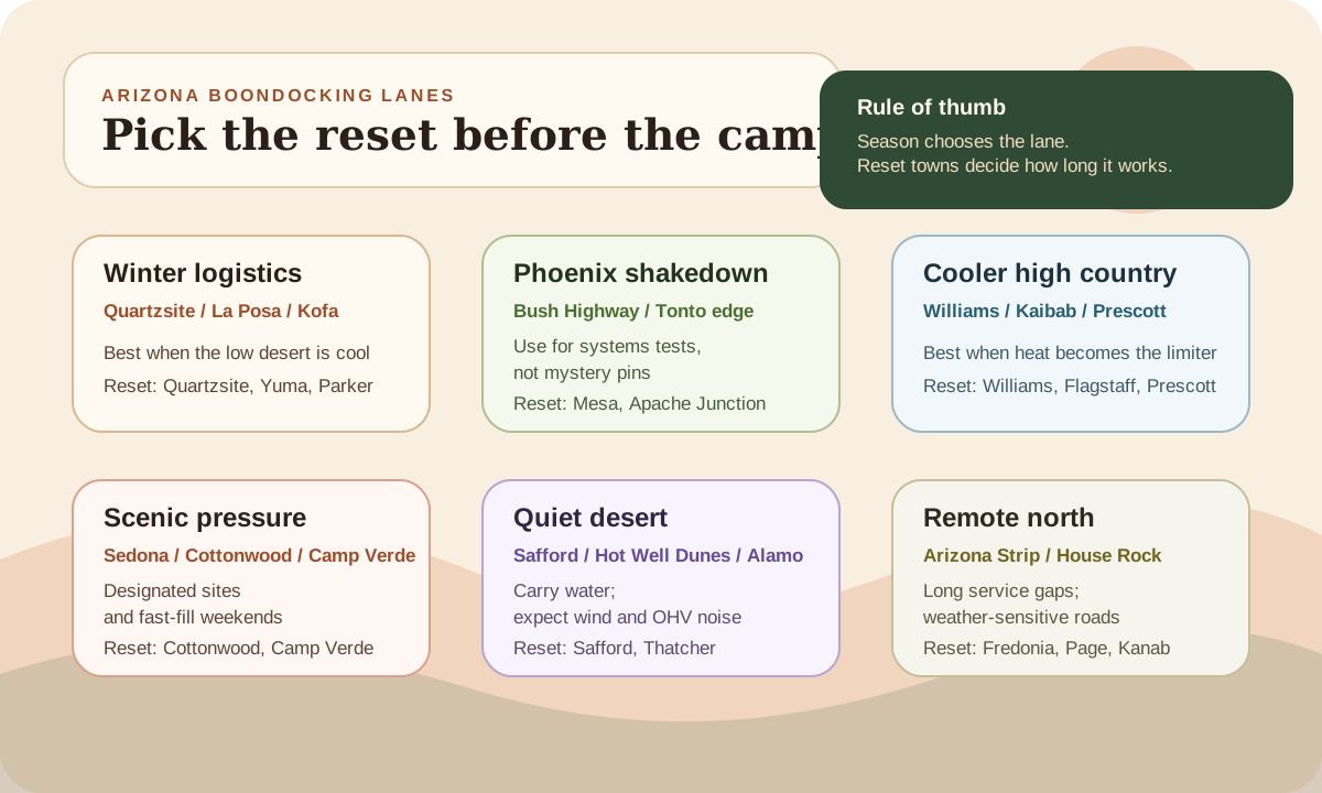
Pick the reset before the campsite
Arizona planning gets simpler when you decide where the trip recovers before you decide where it camps. For each lane, name the town or managed facility that solves water, dump, groceries, fuel, weather, and a legal overnight if the first campsite plan fails.
That changes how you read map pins. A Quartzsite pin with La Posa or town services nearby is a very different risk from a Kofa pin that depends on rough refuge roads and a long water carry. A pretty Sedona pin is not useful if the designated sites are full. A Williams forest road is not a summer escape if monsoon mud removes your exit.
Use the Arizona names as lane labels, not guarantees. Quartzsite is the service-forward winter lane. Kofa is the quieter rough-road lane. Bush Highway is a Phoenix/Mesa shakedown lane. Sedona is a designated-site pressure lane. Williams, Kaibab, and Prescott are heat-escape lanes with forest-road rules. Safford, Hot Well Dunes, and the Arizona Strip are self-contained lanes where the reset plan matters before the view does.
A faster Arizona pre-arrival check
Before leaving pavement, write down the managing agency, the road you can exit after weather, the next water and dump reset, the no-fire cooking plan, and the paid or legal fallback. If one of those is blank, the pin is not ready.
Official planning links
Use these as verification starting points before you commit to a dispersed campsite.
Pre-arrival checks
Confirm the managing agency
Arizona mixes BLM, national forest, state trust, tribal, private, park-adjacent, refuge, and local lands quickly. The exact spot matters.
Check the road after weather
Desert washes, sandy approaches, clay, and high-country forest roads can change fast. If the exit depends on perfect weather, choose a simpler site.
Name the next water and dump reset
Quartzsite, Parker, Lake Havasu City, Flagstaff, Cottonwood, Safford, Yuma, and Page can all be useful reset towns depending on the lane.
Think in Arizona lanes, not one Arizona
Arizona is easier when you choose the lane before choosing the site.
Compare
Arizona boondocking lanes
Use one comparison matrix to scan the practical differences. Small screens stack each row; wider screens keep the first column pinned.
| Spec | Quartzsite / La Posa | Lake Havasu / Parker | Sedona / red rock | Flagstaff / high country | Safford / southeast desert |
|---|---|---|---|---|---|
| Best season | December through February | November through March | Spring and fall weekdays | Late spring through early fall | Late fall through spring |
| Best fit | Longer winter stays with services nearby | Shorter desert-water-route stays | Scenic stops with strict legal checks | Summer heat escape and forest routes | Quieter desert stays with OHV awareness |
| Main watchout | Crowds, dust, wind, and fee/pass rules | Rough washes, crowd pressure, and limited shade | Designated-site rules and no wood or charcoal fires in west Sedona | Seasonal roads, shade, storms, and MVUM restrictions | Remote services, rough roads, heat, and weekend OHV traffic |
| Best reset | Quartzsite for fuel, groceries, dump, water, mail, and repairs | Lake Havasu City, Parker, or Bullhead City depending on route | Sedona, Cottonwood, Camp Verde, or Flagstaff | Flagstaff, Williams, Payson, Show Low, or nearby forest towns | Safford, Thatcher, Willcox, or Bowie |
Compare
Season, surface, and reset planning for named Arizona lanes
Use one comparison matrix to scan the practical differences. Small screens stack each row; wider screens keep the first column pinned.
| Spec | Best broad window | Road and access note | Water / dump reset | Best fallback |
|---|---|---|---|---|
| Quartzsite / La Posa | Late fall through early spring | Flat desert access, dust, wind, and crowd pressure. LTVA permit season runs Sept. 15 to Apr. 15. | La Posa water and dump or Quartzsite town services | Stay inside the LTVA or move to a Quartzsite RV park |
| Kofa NWR | November through March | Refuge roads are mostly unmaintained; camps must stay 1/4 mile from water and vehicles within 100 feet of the road. | Yuma from the south or Quartzsite from the north | Highway 95 commercial overnight or a service-forward stop in Yuma or Quartzsite |
| Bush Highway / Tonto | October through April, especially weekdays | Paved approach, but lots fill early; Water Users is day use only and Bulldog Canyon motorized access needs a permit. | Mesa, Apache Junction, or Fountain Hills | A developed Tonto campground or a paid Mesa-area overnight |
| Alamo Lake | November through April | Paved park approach with open-desert wind; overnight camping stays in designated state-park sites. | Alamo Lake dump stations or Wickenburg and Parker on the drive | Hookup or dry-camp sites inside Alamo Lake State Park |
| Williams / Kaibab | Late May through October | Cinder roads, mud after storms, cold nights, and seasonal forest-road closures. | Williams or Flagstaff | Dogtown, Kaibab Lake, or a Williams private park |
| Prescott Basin | Spring and fall weekdays | Camping only in designated dispersed sites, 7 days in 30, and no potable water or restrooms. | Prescott or Chino Valley | A developed Prescott campground or a private park |
| Salt River Canyon | March through May and October | Steep canyon driving, no-cell stretches, flash-flood risk, and a scenic but rugged corridor. | Globe, Roosevelt, or Show Low | A paid canyon-edge stop before the steepest miles |
Quartzsite and La Posa are the classic Arizona winter RV lane because they make logistics simple. The official La Posa LTVA page lists water faucets, dump facilities, trash services, vault toilets, and paid permit options. That does not make the camping glamorous. It makes it practical. Expect flat desert, dust, wind, neighbors, generators, and crowds around the winter event season. The advantage is that you can practice longer off-grid stays without being far from fuel, groceries, mail, parts, and repairs.
Kofa National Wildlife Refuge is the quieter, rougher west-Arizona alternative. The official refuge rules allow camping, but camps must stay at least a quarter mile from water sources, vehicles must remain within 100 feet of the road, and most refuge roads are not maintained. That makes Kofa a better fit for smaller, self-contained rigs and slower scouting than for a big fifth wheel looking for an easy first Arizona stay.
Lake Havasu, Parker, and the lower Colorado River corridor are more scenic for many travelers, but less forgiving if you pick the wrong access road. Craggy Wash and other Lake Havasu Field Office routes can be popular in cooler months, so arrive early and avoid assuming every side road is legal or RV-suitable. This lane is best when you want a few nights near town services and water-based recreation, not when you want deep solitude.
Bush Highway and the east-of-Mesa Tonto edge work better as a Phoenix-adjacent testing lane than as a classic dispersed-camping lane. The Tonto water-activity pages note that many sites fill by 10 a.m. on weekends, and Water Users itself is day use only. If you want dirt access near Bush Highway, Bulldog Canyon adds an OHV permit layer and designated-route rules that deserve a full read before you drive through the gate.
Sedona is the lane where rule checks matter most. The Coconino National Forest west Sedona designated dispersed area is free and first-come, but camping outside the listed designated areas is prohibited within that system. The official page also notes no potable water or restrooms and prohibits charcoal and wood campfires at all times in that area. That means Sedona is not a casual "pull off wherever the view is nice" destination. Treat it like a limited-slot arrival problem with a Cottonwood, Camp Verde, or paid-campground fallback.
Flagstaff, Williams, Kaibab, Prescott, Apache-Sitgreaves, and the Mogollon Rim are the summer pressure valve. They can be excellent when desert heat becomes the main problem, but they trade heat relief for road season, forest shade, thunderstorms, cinder or mud, colder nights, and motor-vehicle map rules. Use the forest-specific MVUM before driving a large rig past the first good turnaround.
Alamo Lake is not classic free boondocking, but it is an important west-Arizona reset lane. The state-park facilities page lists mixed-amenity sites, dry camping, full hookups, and two dump stations. When wind, road wear, or tank limits make the Havasu or Kofa plan messy, Alamo is the kind of paid fallback that keeps the trip moving.
Hot Well Dunes and the Safford-area desert are a different kind of Arizona. The official BLM page notes that 2026 Great American Outdoors Act work is expected to repair and replace recreation facilities and roads, with periodic impacts to trash receptacles, vault toilets, developed campsites, and active construction areas while dispersed camping and off-roading remain broadly available across most of the area. That turns Hot Well into a check-before-you-go lane, not just a pin to save for later.
The same official page also makes the service reality plain: the area is roughly 35 miles from Safford, the road can get rough, there is no electricity, drinking water, or phone service at the site, and summers are extremely hot. It can work well for cooler-season travelers who understand OHV noise, sand, fees, construction timing, and limited services.
Named Arizona areas worth understanding
The goal is not to publish a list of secret GPS points. The goal is to know what each named area is good at, what can go wrong, and where the next reset lives.
Quartzsite and La Posa LTVA
Use this lane when you want the easiest winter logistics in Arizona. La Posa LTVA is especially useful for newer boondockers because the area is built around long-term winter visitors rather than pretending everyone is on a rugged expedition.
The tradeoff is atmosphere. If you picture complete silence, this may not be your spot. You are choosing convenience, winter sun, parts access, dump/water support, social energy, and a low-risk place to test systems.
The water plan is straightforward because Quartzsite and the LTVA facilities are close by, but do not let that make you sloppy. Wind, dust, and extra showers can still shorten a stay. If you are trying to push beyond a week, use the water conservation guide and decide which habits will actually change.
Kofa National Wildlife Refuge
Kofa National Wildlife Refuge rules make the tradeoff plain. Camping is allowed, but camps cannot be within a quarter mile of water sources, vehicles must remain within 100 feet of the road, and travel is limited to designated roads. The broader refuge visit guidance also warns that most roads are not maintained, many are best for high-clearance or four-wheel-drive vehicles, there is no sanitation or drinking water on the refuge, and cell coverage is absent over most of the area.
That makes Kofa a real Arizona option, but not a generic one. For vans and smaller trailers, it can be a quieter Sonoran lane with big-sky camping and fewer neighbors than Quartzsite. For larger RVs, it usually works better as a scout-first lane with Yuma or Quartzsite already named as the reset and fallback.
Lake Havasu, Craggy Wash, and Parker
This lane works best as a scenic winter or shoulder-season stop with town access. Lake Havasu City and Parker make reset planning easier than many remote desert areas. The difficulty is popularity and road condition.
Do not assume a road that worked for a van is good for your trailer or Class A. Washboard, embedded rock, soft shoulders, and crowded turnarounds are common enough that you should scout conservatively. If the site requires backing through camp clutter or turning around in loose material, pick a less dramatic spot closer to the main road.
This lane also needs a no-drama paid fallback. Lake Havasu, Parker, Buckskin Mountain, Cattail Cove, and private RV parks can be expensive or full in season, but having a real backup is better than pushing down a rough wash near dark.
Alamo Lake State Park as the western Arizona reset
Alamo Lake State Park belongs in this guide because it solves the part of western Arizona that many free-camping lists ignore: what you do when you need a legal overnight with real services before the next public-land move. The park publishes mixed-amenity sites, dry-camp areas, full-hookup sites, a park store, and two dump stations.
That makes Alamo less like boondocking itself and more like the clean reset anchor for west-Arizona loops. If Kofa is too rough, Havasu is too crowded, or your tanks are done, Alamo lets you rebuild water, trash, dump, and power without burning a full day in town.
Bush Highway, Lower Salt, and the Tonto edge-of-town lane
The Bush Highway side of Tonto National Forest is useful because it lets Phoenix-area RVers test a public-land routine without driving across the state. It is not the same as a deep dispersed-camping lane. Water Users Day Use Area is day use only, has no potable water, and the Forest Service warns that it can reach capacity on busy weekends. The broader Tonto water-activities page says many sites fill by 10 a.m. on weekends.
If you want dirt-road access from Bush Highway, the Bulldog Canyon OHV Permit Zone adds a different rule set: designated routes only, off-road driving prohibited, and a Tonto OHV permit required for motorized use. Use Mesa, Apache Junction, or Fountain Hills as the reset plan and keep a developed Tonto campground or paid valley overnight as the clean fallback.
Phoenix/Mesa starter loop for a first Arizona shakedown
If you are leaving from Phoenix, Mesa, Gilbert, Chandler, Tempe, or Apache Junction, do not make your first Arizona boondocking test a remote Kofa or Arizona Strip run. Use the local edge as a controlled systems shakedown first.
The clean version is simple: fill water and handle dump needs before you leave town, scout the Lower Salt or Bush Highway corridor in daylight, and treat Bulldog Canyon as a permit-and-route-readiness check rather than a casual free-camping promise. Water Users is day use only, many river-access points fill early, and motorized access inside Bulldog Canyon stays on designated routes. That means the local loop is best for testing shade, battery use, fridge behavior, tire pressure, recovery gear, dust control, and how the rig feels on rougher access roads.
For the overnight, name the legal plan before you roll. That might be a developed Tonto campground, a state park or private paid fallback, a different legal dispersed area, or a move toward cooler forest lanes once the system test is done. The point is not to force an overnight beside the closest pretty water. The point is to use the Phoenix/Mesa edge to find weak spots while Mesa, Apache Junction, Fountain Hills, and Payson are still realistic reset options.
West Sedona and Cottonwood
Sedona is beautiful enough to make people override their own judgment. That is exactly why you should slow down here.
West Sedona designated dispersed camping is a managed, designated system. If the legal sites are full, the answer is not to create a new site or use a closed pullout. The answer is to move to a legal fallback, change the timing, or pay for a campground.
Water and dump logistics usually point toward Cottonwood, Camp Verde, Sedona services, or Flagstaff depending on your route. Plan that reset before you commit to multiple nights because the designated sites themselves do not provide potable water or restrooms.
Williams, Kaibab National Forest, Flagstaff, and the Mogollon Rim
The high-country lane is about heat relief, not guaranteed ease. Kaibab National Forest's district pages are useful here because they identify the real service pattern. Williams, Tusayan, and Flagstaff support the south Kaibab. Fredonia and Kanab support the north. Around Williams, the forest includes the largest contiguous ponderosa pine forest in the world plus the Kaibab, Dogtown, White Horse, and Cataract lake areas.
That is good summer logic, not automatic easy camping. The Williams Ranger District has no perennial streams and only a few reliable springs, so this is not a lane to assume on-site water from the landscape. Expect cinder roads, monsoon mud, colder nights, and big solar differences between open clearings and pine shade. If you work remotely, pair this lane with the internet backup planner before assuming trees and canyon walls will be kind to your signal.
Arrive with daylight and reject roads early. The prettiest high-country site is not worth a long reverse on a one-lane road after storms build.
Prescott Basin and Prescott National Forest
Prescott Basin designated dispersed camping is one of the clearest rule sets in Arizona. The Forest Service says camping and campfires are allowed only in designated campsites within the basin, stays are limited to 7 days in a 30-day period, and potable water plus restrooms are not available at the sites.
That makes Prescott Basin easier to plan than rumor-heavy free-camping posts suggest. Use Prescott or Chino Valley for water, dump, groceries, and propane. This lane works best when you want cooler weather without driving all the way to Flagstaff, but it punishes last-light arrivals and vague site plans.
Salt River Canyon and the Globe-to-Show Low transition
Salt River Canyon Wilderness is one of the strongest scenic terms in Arizona travel planning, but for RVers it is better treated as a rugged transition lane than as a casual first boondocking base. The Forest Service describes the canyon as very rugged, notes that the free-flowing river can rise to flood stage quickly, and uses permits for spring boating through the wilderness from March 1 to May 15.
The practical move is to use Salt River Canyon as a route-planning keyword. Stop before the steepest descent if weather or road comfort is marginal, carry water from Globe or Show Low, and keep a paid overnight named if canyon wind, runoff, or no-cell conditions make the timing feel wrong.
Safford, Hot Well Dunes, and southeast Arizona
Southeast Arizona is useful when you want winter desert without the Quartzsite crowd. Hot Well Dunes is a named BLM recreation area with primitive camping options, but it is also an OHV area and, during the current 2026 facility-and-road work window, a construction-awareness area. That means the right site depends on whether you can tolerate vehicle noise, sand movement, possible amenity impacts, and a less predictable developed-site layer.
The official BLM page is plain about the service reality: no drinking water, no electricity, no phones, rougher access at times, and extreme summer heat. It also says visitors should expect periodic impacts to trash receptacles, vault toilets, and developed campsites during construction. Treat Safford, Thatcher, Bowie, or Willcox as the reset lane, pack out trash if services are affected, and do not arrive with a nearly empty fresh tank.
Arizona Strip, House Rock Valley, and northern routes
The Arizona Strip is not just "more desert north of the Grand Canyon." It is a remote-lane decision with long service gaps, winter weather exposure, clay roads, monument and wilderness boundaries, and fewer casual fallbacks.
House Rock Valley Road, Vermilion Cliffs approaches, Fredonia, Page, and Kanab all show up in northern Arizona route planning, but not every scenic pullout is legal or RV-smart. Some roads cross monument, wilderness, refuge, private, tribal, state, or managed recreation boundaries. Some surfaces can turn ugly after rain or snowmelt.
This lane is best for self-contained travelers who already have water, fuel, tires, and a paid fallback named. If you need an easy first Arizona public-land test, start with Quartzsite or a service-forward desert lane instead.
State Trust land is not a generic backup plan
Do not confuse Arizona State Trust land with BLM land
Arizona State Trust land has its own recreation permit terms. The official permit terms limit recreational camping and require compliance with State Land Department directions and fire restrictions. It can be part of a legal plan, but it should not be treated as an automatic free dispersed-camping substitute for BLM or national forest land.
This matters around Phoenix, Tucson, Sedona, and fast-growing desert edges where land ownership changes quickly. If your app layer says "state trust," stop and verify the permit, restrictions, access route, and whether overnight camping is actually allowed for your use.
The same caution applies to tribal land, national parks, wildlife refuges, military-adjacent areas, and private inholdings. Arizona has huge public-land opportunity, but the boundaries are not decorative.
Road conditions decide more than map distance
Arizona road problems usually come from one of five surfaces:
- washboard desert access roads
- sandy or loose wash crossings
- clay that becomes ugly after rain
- rocky forest roads with poor turnarounds
- paved approaches that look easy until snow, wildfire, flooding, or construction changes the route
Dry does not always mean easy. A 5-mile washboard road can shake cabinets loose and turn a pleasant arrival into a repair list. Wet does not always mean passable later. A short clay stretch can become the reason you stay an extra day whether you wanted to or not.
For larger RVs, the safest Arizona habit is to stop at the first obviously workable site instead of driving past it for a maybe-better one. If the road is narrowing, the surface is changing, or the turnaround options are disappearing, you already have the information you need.
Water, heat, and solar need to be planned together
Arizona is sunny, but sunny does not automatically mean easy.
Heat increases water use, fridge runtime, fan use, pet needs, and the amount of rinsing you do just to keep dust under control. Parking for shade can make the living space better and the solar day worse. Parking for solar can cook the rig by midafternoon.
The cleanest pattern is to decide which resource is controlling the stay before you arrive:
- If water is the governor, stay closer to Quartzsite, Parker, Lake Havasu, Flagstaff, Cottonwood, Safford, or another reset town.
- If heat is the governor, move up in elevation or shorten the stay.
- If power is the governor, use the solar calculator and do not let tree shade or panel heat surprise you.
- If road access is the governor, stop earlier and leave yourself a clean exit.
Arizona trips often fail because someone plans for the campsite photo and not for day three. Day three is when trash, gray water, pet water, dust, and a warm fridge all become more important than the view.
Fire restrictions and no-fire cooking
Arizona fire rules vary by agency, district, county, forest, season, and local order. The BLM Arizona page also carries year-round prevention rules for incendiary devices, and seasonal restrictions can appear or disappear as conditions change.
Build your Arizona food plan so a campfire is optional. Carry a stove setup that works under the current order, confirm whether charcoal is allowed, and do not assume a metal fire ring makes fire legal.
In west Sedona designated dispersed areas, the official Forest Service page prohibits charcoal and wood campfires at all times while allowing certain gas stoves and grills that can be turned on and off. That is the kind of local detail that broad boondocking advice misses.
The Arizona fallback plan
A good Arizona route has two fallback types.
The first is a legal-camping fallback: an LTVA, BLM developed campground, forest campground, state park, private RV park, or a different legal dispersed area. This protects you when Sedona is full, the Lake Havasu road is worse than expected, a forest road is closed, or a fire order changes your plan.
The second is a logistics fallback: water, dump, fuel, groceries, propane, mail, parts, and a place to sit out weather. Quartzsite, Parker, Lake Havasu City, Flagstaff, Williams, Cottonwood, Camp Verde, Payson, Show Low, Safford, Willcox, Yuma, Page, and Tucson all matter more as reset points than as map labels.
If the fallback is vague, the campsite is not ready.
The cleanest Arizona strategy
Use the low desert when the weather is cool.
Move up when heat becomes the limiting factor.
Treat Sedona and other high-pressure scenic areas as designated-site problems, not open-land problems.
Choose camps that are legal, previously disturbed, easy to exit, close enough to a known water reset, and still comfortable if wind or fire restrictions remove the romantic parts of the plan.
That strategy may skip a few dramatic pins. It also keeps Arizona from becoming a story about heat stress, mud, enforcement, or driving deeper because the first site did not look special enough.
If the next leg runs west through bigger service gaps, compare this with the Nevada boondocking guide. If the route turns east toward windier basin and mountain-edge camps, use the New Mexico boondocking guide before carrying Arizona winter-desert assumptions across the line.
Frequently asked
Questions RVers usually ask next.
What are the best Arizona boondocking areas for RVers?
Quartzsite and La Posa are the easiest winter logistics lane. Kofa is a rougher refuge option, Lake Havasu and Parker work well for shorter scenic desert-water routes, Bush Highway and Tonto are useful for Phoenix-area practice but not classic dispersed camping, Prescott and Williams or Kaibab are stronger cooler-weather lanes, and Safford-area desert sites can be quieter if you plan water and road access carefully.
When is the best time to boondock in Arizona?
For low-desert RV boondocking, late fall through early spring is usually the easiest broad window for places like Quartzsite, Kofa, Lake Havasu, Alamo Lake, and Safford. Once heat builds, many RVers move toward higher-country forest routes near Prescott, Flagstaff, Williams, the Mogollon Rim, Kaibab, or Apache-Sitgreaves.
Can I boondock anywhere on Arizona BLM land?
No. Many BLM areas allow dispersed camping, but local closures, special recreation areas, long-term visitor areas, fire orders, wilderness boundaries, and posted restrictions still matter. Confirm the exact field office and site rules before relying on a map pin.
Is Sedona good for free RV camping?
Sedona can work, but it is not casual. West Sedona uses a designated dispersed-camping system, sites are first-come, camping outside the designated areas is prohibited, and there is no potable water or restroom service at the sites.
Freshness note
Last checked April 29, 2026
This topic can change when products, plans, prices, campsite rules, or fit guidance move. These notes show what was reviewed most recently.
This review included
- Rechecked official La Posa LTVA, Kofa NWR, Tonto Water Users, Bulldog Canyon, West Sedona designated dispersed camping, Alamo Lake State Park, Kaibab Williams Ranger District, Prescott Basin, Salt River Canyon, Hot Well Dunes, Arizona fire restrictions, Arizona State Land permit terms, and AZ511 pages on April 29, 2026.
- Added the current Hot Well Dunes 2026 facility and road work note so southeast Arizona planning reflects possible trash, vault-toilet, developed-campsite, and construction-area impacts.
- Rechecked and normalized the Arizona article, boondocking hub, and homepage-facing metadata path so the guide publishes one current update state instead of old 4-minute, 6-minute, or April 18 variants.
- Rechecked official La Posa Long Term Visitor Area permit and facilities details, Kofa National Wildlife Refuge road and camping rules, Prescott Basin designated dispersed camping rules, Tonto Bush Highway and Bulldog Canyon access conditions, Alamo Lake State Park facility and dump-station details, Kaibab and Williams district routing, Salt River Canyon permit and hazard notes, Hot Well Dunes access, Arizona State Land recreation permit terms, BLM Arizona fire restrictions, and AZ511 road-condition routing.
- Checked official BLM Arizona, La Posa LTVA, Kofa refuge rules, Tonto National Forest day-use and OHV permit pages, Coconino west Sedona designated dispersed camping, Prescott Basin designated dispersed camping, Kaibab district information, Salt River Canyon wilderness permit details, Arizona State Parks Alamo Lake facility pages, and Arizona State Land recreation permit terms.
- Expanded the guide with named Arizona lanes including Quartzsite, Kofa, Bush Highway, Alamo Lake, Williams, Prescott, Salt River Canyon, Safford, and the Arizona Strip.
- Added a season, surface, and reset table so readers can compare Arizona water and dump strategy, road realities, and fallback moves before choosing a lane.
- Added an Arizona-specific lane-board visual and reset-first planning section so readers choose the recovery town before chasing campsite pins.
Recent change log
April 29, 2026
Rechecked official Arizona land-manager pages, refreshed the published metadata state, and added the current Hot Well Dunes 2026 construction-impact note.
April 21, 2026
Normalized the Arizona guide metadata across article, hub, and homepage surfaces, added a Phoenix/Mesa starter loop, and added a reset-first Arizona lane board.
April 20, 2026
Expanded the guide with Quartzsite, Kofa, Bush Highway, Alamo Lake, Williams, Prescott, and Salt River Canyon planning notes, then refreshed the official-source links and reset guidance.
April 18, 2026
Deepened the Arizona guide with Phoenix/Mesa route lanes, current official-source notes, more named-area guidance, and stronger legal, road, water, and fallback planning details.
April 15, 2026
Expanded the Arizona guide with named areas, official-resource checks, water-reset strategy, road cautions, fire-status guidance, and fallback options.
April 14, 2026
Reworded the seasonal planning framework so it reads less like internal site jargon and more like practical route advice.
April 10, 2026
Added official planning links and a pre-arrival checklist for Arizona dispersed-camping research.
Broader editorial corrections are tracked on the Corrections and Updates page.


